
Competition Instructions
National Compass Event, Junior League Final and National Orienteering Competition – Sunday, 23 August 2026, Kontiolahti


20.8. updated information in red color.
Competition Rules
The competition will be conducted in accordance with the Finnish Orienteering Federation (SSL) competition rules and the instructions issued by the organizers. Participants compete at their own risk.
Event Centre, Directions and Parking
The event center is located at the Kontiolahti Biathlon Stadium, Napakympintie 24, 81100 Kontiolahti.
Directions to the event center:
- From the direction of Joensuu: take the exit from Highway 6. Driving time approximately 15 minutes.
- From the direction of Kajaani: from the junction of Highway 6 and Regional Road 73. Driving time approximately 10 minutes.
Directional signs will be in place from Friday, 21 August at 16:30.
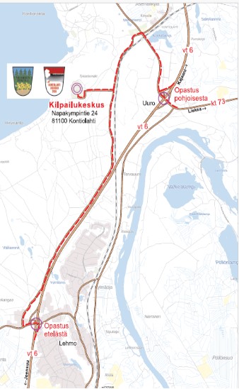
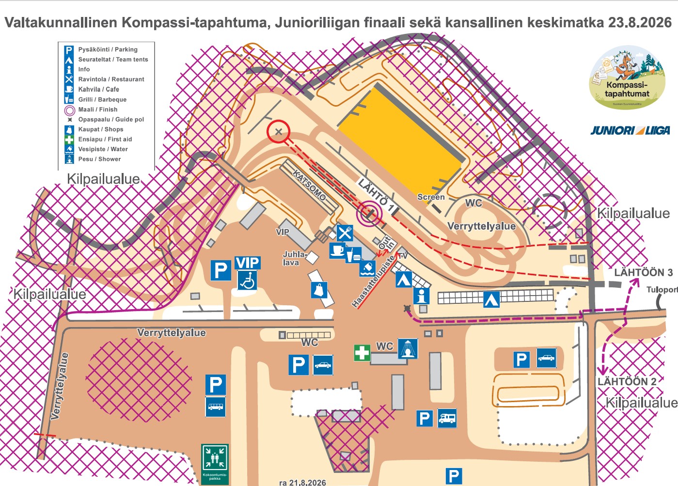
The walking distance from the parking area to the event center is a maximum of 500 m.
The parking fee is €5/day. The parking ticket can be purchased at Competition Info and must be displayed on the windscreen when leaving the parking area.
Parking for buses is free of charge. Please notify the organizers of arriving buses in advance at nuju2026@kalevanrasti.fi.
Event Centre Map
Competition Materials
Competition bib numbers and Emit check cards are available near Competition Info at the event center. Please bring your own safety pins to attach the bib number. Rental Emit cards (€5) are available from Competition Info, where they must also be returned. A fee of €80 will be charged for an unreturned card.
No competition bib numbers are used in the national classes.
Each competitor is responsible for ensuring that they compete with the Emit card registered for them and that the card is functioning properly. You can test your card using the Emit zeroing unit located at the information pole in the event center.
Changes to Emit card numbers must be reported to the Competition Info no later than one hour before the competitor’s start time.
Start Times
Start lists will be available on the Youth Jukola 2026 website by 18:00 on 20 August 2026.
Starts, Classes, Course Lengths and Number of Controls
Start 1
Mass starts for H/D14 and pursuit starts for H/D16 and H/D18.
The start is located at the event center.
Mass starts from 10:00 onwards, pursuit starts from 11:00 onwards.
| Class | Distance (km) | No. of controls | Scale | Start type | Start time |
| H14 | 5.1 | 15 | 1:10 000 | Mass start | 10:00 |
| D14 | 4.6 | 15 | 1:10 000 | Mass start | 10:20 |
| H16 | 5.0 | 15 | 1:10 000 | Pursuit start | from 11:00 |
| D16 | 4.8 | 14 | 1:10 000 | Pursuit start | from 11:10 |
| H18 | 5.6 | 21 | 1:10 000 | Pursuit start | from 11:20 |
| D18 | 5.2 | 17 | 1:10 000 | Pursuit start | from 11:30 |
Junior League Pursuit Starts
-
- 5 min – call-up to the starting pen
- 4 min –
- 3 min – Emit zeroing
- 2 min –
- 1 min – wait for the start signal
Competitors who have no points before the final will start at intervals according to the following schedule: H16 from 11:10, D16 from 11:20, H18 from 11:30 and D18 from 11:40.
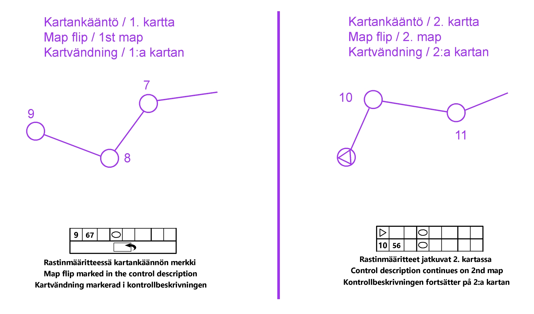
Competitors in the H/D16 and H/D18 pursuit classes take the map corresponding to their competition number after receiving the start signal. The course includes a map turn. Control numbering is continuous, meaning that control number 1 appears only on the first map.
The map is folded in the map holder so that the first part of the course is on the inside of the fold.
Mass Start for the Kultakompassi (Golden Compass) Classes
Competitors in the Kultakompassi (Golden Compass) classes enter the start area via the Emit zeroing point. Four minutes before the start, competitors line up in rows of 10 in numerical order. Maps will be handed out two minutes before the start. In the mass starts for classes D14 and H14, the map is handed out rolled up. The rubber band around the roll is removed upon the organizer’s instruction once everyone has received their maps, and the organizer collects the bands before the start. The rolled map may only be opened at the moment of start. The start signal will be given by announcement.
The course includes a map turn. Control numbering is continuous.
Late competitors must report to the LATE COMPETITORS/MYÖHÄSTYNEET sign. No time compensation will be given for lateness.
Start 2
Normal Interval Starts – H/D10RR and H/D12
The distance to the start is approximately 400 m from the information pole. The route is marked with red tape and directional arrows.
Interval starts from 10:00 onwards.
| Class | Distance (km) | No. of controls | Scale |
| H10RR | 2.9 / 1.9 | 6 | 1:10 000 |
| D10RR | 2.9 / 1.9 | 6 | 1:10 000 |
| H12 | 3.1 | 9 | 1:10 000 |
| D12 | 2.9 | 8 | 1:10 000 |
| H12TR | 2.2 | 7 | 1:10 000 |
| D12TR | 2.2 | 7 | 1:10 000 |
The K-point is located at the start.
At the final control, competitors may punch either control RR6 or control 170.
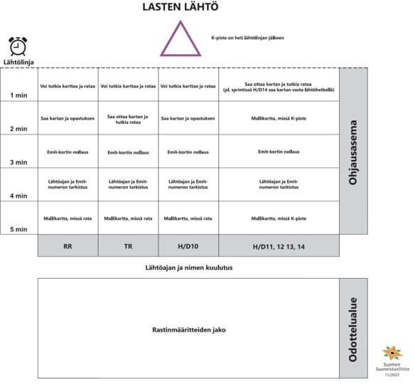
The Silver and Bronze Kompassi classes follow the SSL special instructions for children’s starts, shown in the image below.
Additional Instructions for the String Course and Supporting String Course
The string course is marked on the ground with white plastic tape (string). The string is shown on the map in orange. The controls on the RR course are numbered in sequence on the map. In the terrain, the corresponding codes RR1, RR2, etc. are displayed next to the control units. The RR codes are also shown on all sides of the control flags. A missing punch on an RR course does not result in disqualification. Instead, 10 minutes will be added to the competitor’s time for each missing correct punch.
The supporting string course uses normal control codes. Controls belonging to other courses may be located close to the string, so remember to check the control code before punching. Punching at an incorrect control does not matter as long as all your own controls are punched in the correct order.
Special Instructions for the Open String Course
The Open String Course starts from its own starting pen at Start 3. The distance to the start is 300 m, marked with blue tape.
Please note that the Open String Course starts from a different start location than classes H/D10RR and H/D12TR.
Procedure at the Open String Course Start
-
- 5 min – call-up to the starting pen; model map with the course
- 4 min – check of start time and Emit number
- 3 min – Emit card zeroing
- 2 min – map and instructions
- 1 min – time to study the map and course
The map and course for the Open String Course will be published on the event website on Saturday, 22 August at 18:00 after the Youth Jukola has finished. The string and controls for the Open String Course are completely separate from those used for the H/D10RR and H/D12TR classes. The strings only meet at the final control. If necessary, a companion may accompany a competitor on the Open String Course.
National Classes (H/D21 and older): Start 3
The distance to the start is approximately 300 m from the information pole. The route is marked with blue tape. Interval starts from 10:00 onwards.
Procedure at the Start
-
- 5 min – call-up to the starting pen
- 4 min –
- 3 min – Emit zeroing
- 2 min –
- 1 min – proceed to the maps
The map may be taken at the start signal. The H21 course includes a map turn. Control numbering is continuous.
| Class | Distance (km) | No. of controls | Scale |
| H21 | 6.5 | 22 | 1:10 000 |
| D21 | 5.6 | 19 | 1:10 000 |
| H35 | 5.2 | 18 | 1:10 000 |
| H40 | 5.2 | 18 | 1:10 000 |
| H45 | 5.1 | 19 | 1:7 500 |
| H50 | 5.0 | 18 | 1:7 500 |
| H55 | 4.9 | 16 | 1:7 500 |
| H60 | 4.5 | 14 | 1:7 500 |
| H65 | 4.3 | 13 | 1:7 500 |
| H70 | 3.6 | 10 | 1:7 500 |
| H75 | 2.6 | 11 | 1:7 500 |
| H80 | 2.1 | 8 | 1:7 500 |
| H85 | 1.7 | 8 | 1:7 500 |
| D35 | 5.1 | 19 | 1:10 000 |
| D40 | 4.9 | 16 | 1:10 000 |
| D45 | 4.9 | 16 | 1:7 500 |
| D50 | 4.1 | 13 | 1:7 500 |
| D55 | 4.1 | 13 | 1:7 500 |
| D60 | 3.1 | 11 | 1:7 500 |
| D65 | 3.1 | 11 | 1:7 500 |
| D70 | 2.6 | 11 | 1:7 500 |
| D75 | 2.1 | 8 | 1:7 500 |
| D80 | 2.1 | 8 | 1:7 500 |
| D85 | 1.7 | 8 | 1:7 500 |
| Open RR | 1.7 / 2.5 | 6 | 1:7 500 |
Map
Orienteering map, scale 1:10,000 (classes H/D40 and younger) or 1:7,500 (classes H/D45 and older), contour interval 5 m. Printed map. Map size A4. Maps are provided in plastic map cases.
Mapmaker: Jussi Silvennoinen, 2025. Updated 07/2026.
The previous version of the map of the area is available on the event website.
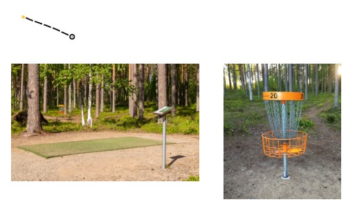
Disc golf baskets are shown on the map using symbol 526.0, Boundary Stone. Disc golf throwing platforms are shown using symbol 401.0, Open Land. An example of the map representation of the disc golf course is shown below.
The special feature symbol  indicates a tar-burning pit. A tar-burning pit is a circular depression with a surrounding earth bank rising up to approximately one meter above the surrounding terrain. The diameter of a tar-burning pit is approximately 6–10 meters.
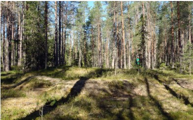
Photo: Metsähallitus.
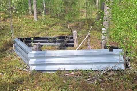
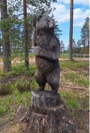
The special feature symbol  indicates a paintball shooting shelter or statue.
The final control is also marked on the map with a special feature symbol . In this case, the symbol represents an advertising flag placed by an event partner.
Terrain
The competition terrain mainly consists of easily runnable, pine-dominated forest terrain. Near the shore of Lake Höytiäinen, the ground is rocky in many places.
There are numerous tracks and paths, and it has not been possible to map all minor paths. The elevation differences are generally moderate, although differences of up to approximately 40 meters can also be found.
The competition terrain contains numerous features dating from the former Kontioranta garrison, which was closed in 2013, including a disused shooting range area. It is permitted and safe to move through the shooting range area.
The longest courses also include more detailed and, in places, more overgrown terrain.
There are some fences in the terrain. Some fences are shown using the standard fence symbol (516.0). These fences can be easily crossed or passed underneath, even by the youngest competitors.
Fences shown using the impassable fence symbol (518.0) cannot be crossed, even though crossing them would otherwise be permitted according to the competition rules.
Forbidden Areas
There are several forbidden areas in the terrain, marked on the map with the forbidden symbol.
If a forbidden area is shown on the map with a continuous boundary line, it is also marked in the terrain with continuous tape.
There is a stored snow pile covered with sawdust in the biathlon stadium area. It is marked as forbidden area on the map and with tape in the terrain. Climbing onto the pile is prohibited for safety reasons.
Road Crossings
There are several roads in the competition area with occasional vehicle traffic. The courses also cross Taskisentie, which is shown on the competition map using the brown road symbol (major road). Taskisentie is not a through-drive road. All roads may be used freely during the competition, and no designated crossing points have been arranged.
Exercise normal caution when crossing roads!
Warm-up
Warm-up is permitted along the marked routes to the starts. The event center is located in the middle of the competition terrain. Therefore, warm-up outside the event center is permitted ONLY along Taskisentie southwards from the event center. The location of the permitted warm-up area and its end-point on the road are marked with signs. The forest on both sides of the road is part of the competition area, so leaving the road is prohibited.
Forking
The mass-start and pursuit classes H/D14, H/D16 and H/D18 use so-called diamond forking.
Finish
All competitors use the same final control. Competitors in the mass-start and pursuit classes (Start 1) punch at the final control and run to their designated finish lane.
The finishing order is determined by the finish judge at the finish line. After crossing the finish line, competitors perform a finish punch in the order in which they cross the finish line.
Competitors in interval-start classes (Starts 2 and 3) punch at the final control and continue to their designated finish lane. A finish punch is performed at the finish.
The finish closes at 15:00.
Rental Emit cards must be returned to the Competition Info immediately after finishing. An €80 fee will be charged for an unreturned Emit card.
GPS Tracking
GPS tracking will be used in the Junior League Final. The list of competitors to be tracked will be published on https://jukola.com/nj2026/ by 22 August 2026 at the latest.
GPS vests and devices are available at the check-in tent. The vest may be collected in advance. GPS vests and devices must be returned immediately after finishing. Competitors may use their own GPS vests. Please allow sufficient time to collect the device!
The use of personal GPS devices with displays during competition is prohibited.
The competition GPS tracking will be displayed on the screen at the event center. GPS tracking will open at approximately 11:30.
Personal GPS Devices
A personal GPS device or its data may not be used to assist your own or another competitor’s performance or shared during the competition. See section 3.54 of the competition rules.
A route recorded by a GPS device or watch may not be published (e.g. on Strava) before the competition has ended.
Retirements
Competitors who retire must come to the finish as normal and report their retirement at the finish.
Map Return
Maps will not be collected at the finish. Showing the competition map or discussing the course with competitors who have not yet started is prohibited.
Changing, Showers and Toilets
There are portable toilets at the event center and in the exchange area. Additional toilets are available in the washroom facilities and at the end of the service building. Showers are available in the service building. Studded shoes are strictly prohibited inside the buildings.
Prizes
Prizes for the Junior League and Compass event will be presented on the prize-giving stage once the results have been confirmed.
In the Compass classes, places 1–7 will be awarded prizes.
In addition, the best regional team in the Kultakompassi class and the best regional team in the entire Compass event will receive perpetual trophies.
Competitors in the Compass classes will receive a participation prize donated by SSL upon finishing.
In the Junior League overall competition (pursuit), the top seven competitors in each class will receive prizes. In addition, the fastest competitors of the day in these classes will be awarded.
Prizes for the national classes can be collected from the Competition Info once the results have been confirmed.
The number of prize winners will be displayed at the Competition Info.
Kultakompassi Regional Competition
In addition to the individual competition, the Kultakompassi classes have their own regional team competition. The combined points of the three best girls and three best boys from each region will count towards the result. The winning region will hold the Kultakompassi perpetual trophy for one year.
Overall Regional Competition
Every participant in the Compass event has the opportunity to score points for their own region. The top 40 competitors in each class can score points. For the regional competition, the points of the three best competitors from each region in the Gold, Silver and Bronze Compass classes will count towards the result. The winning region will hold the Kompassi perpetual trophy for one year. The perpetual trophies will be presented during the prize-giving ceremony.
Competition Info
The Competition Info is open from 08:00 to 16:00.
First Aid
The location of the first aid point is marked on the event centre map and indicated by signs at the event centre. In an emergency, contact the emergency services directly by calling 112.
Restaurant
The event centre has a restaurant, café and grill.
A meal costs €11 when ordered in advance and €13 when purchased at the restaurant.
On Sunday, the restaurant is open from 10:30 to 15:00 and the grill café from 08:00 to 15:00.
Payment can be made in cash, by card or with MobilePay.
Meal tickets can be purchased in advance from the online shop until 19 August 2026.
On Sunday, the restaurant will serve minced meat lasagnette and vegetarian lasagnette.
The meal includes a fresh salad, bread, spread, water and juice.
Water Point
There is a water point at the event centre.
Safety
Making open fires, using gas or Trangia stoves, and smoking at the event center are strictly prohibited. The disc golf course in the area is closed for the duration of the event.
Youth Jukola 2026 Rescue and Safety Plan
Club Tents
Club tents will be erected in the locations allocated according to advance reservations.
A location map will be published on the website. Particular attention must be paid to securing the tents properly. Tents must remain securely in place even in the event of severe weather. If weather conditions are challenging, the organizers may impose restrictions on erecting tents or specify when they may be erected. Overnight stays at the event center are prohibited.
Training Maps
The organizer offers two official Youth Super Weekend training sessions. The training terrains are Ollinkangas and Lykynlampi, with Youth Super Weekend course planner Santeri Silvennoinen responsible for the courses.
In addition, an official model event will open on Thursday, 20 August, in the immediate vicinity of the competition terrain, on the Kontioniemi map.
Maps for the training sessions and model event are available at the online shop.
Individual training and model event maps can also be purchased from the Youth Jukola Competition Info:
-
- Friday, 21 August, 17:00–20:00
- Saturday, 22 August, 10:00–20:00
- Sunday, 23 August, 08:00–16:00
Cleanliness and Waste
Dropping litter at the event center or in the competition terrain is prohibited. All waste must be placed in the designated collection bins. Please follow the waste-sorting instructions.
Lost and Found
Found items should be taken to Competition Info, where they can be inquired about and collected upon providing identifying details. After the competition, enquiries about lost property can be made by email at office@kontiolahtibiathlon.com.
Photography
Photographs and videos will be taken during the competition. They may be used in competition publications as well as in materials for future competitions and other events.
Protests and Reports of Rule Violations
Protests and reports of rule violations must be submitted in writing to Competition Info in accordance with the competition rules. They will be forwarded to the competition management, Technical Advisor and Jury for consideration and decision.
Competition Organisation and Officials
Organising clubs: Kalevan Rasti and Kontiolahden Urheilijat
Contact: nuju2026@kalevanrasti.fi
Event Director: Arja Makkonen, +358 50 405 1610
Course Planner: Santeri Silvennoinen
Course Controller: Risto Vairinen
Technical Advisor: Mika Kantola, kuntsi.kantola(at)gmail.com, +358 40 738 1901
Communication and media: Sari Jormanainen, viestinta@kalevanrasti.fi
Competition Info: Laura Pastinen
Results: Timo Kokkens
Finish Judge: Aaro Asikainen
Chief of Results Enquiries: Urpo Väänänen
Restaurant: Sanna Kinnunen
Jury: Petri Paukkunen (chair), Mervi Ikonen, Antti Ekonoja
Welcome!