


Training Areas 2018
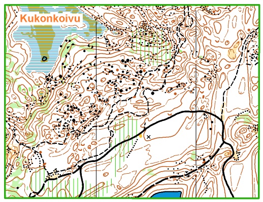
There will be nine training maps made available during the summer, one of which “Lahti Sports Center”, will not have any control point. The training areas will be opened at the end of April depending on the capacity of the parking places. ore detailed dates will be found with the introductions of the areas. The parking site at Kukonkoivu will be closed after 12th June 2018. There will be a substitute parking place in Kukonkoivu during 13th June till 14th June, see the map lower. 15th and 16th June the terrain is available only from Jukola competition center.
Please follow all parking instructions and keep the parking areas clean; thanks in advance.

Maps: sizeA4, scale 1:10 000, ISOM2017 symbols, control descriptions on the map.
Cost of the maps: 7 €/each. Sending by post 6 €/order.
Control markers: small control markers in Tapanila, normal-sized control markers in the other areas.
Parking: marked on the orienteering maps and on the location maps on the web page.
Training at night: The control points are equipped with reflectors for night training at Tapanila, Vihattu, Santaveräjä, Kukonkoivu and Kukkolanharju.
Questions about the trainings: Juha Hirvonen, +358 443138088, jusbelius@hotmail.com
and Aleksi Anttolainen, +358 445050293, aleksi.anttolainen@live.fi.
Ordering of the maps: Jukola2018 office: toimisto.2018@jukola.com, Lahti Sports Center, Salpausselänkatu 8, 2nd Floor, 15110 Lahti. Office opening hours Mon-Fri 9-16.
Last post dates of maps on 8.6.2018.
Wed 13.6. the office is open only from 14 to 16 and Thu 14.6. from 9 to 12.
Map Sales from Information Center at Competition Center: Maps can be bought from the Info tent at Competition Center. Opening hours Fri 10-
TERRAINS:
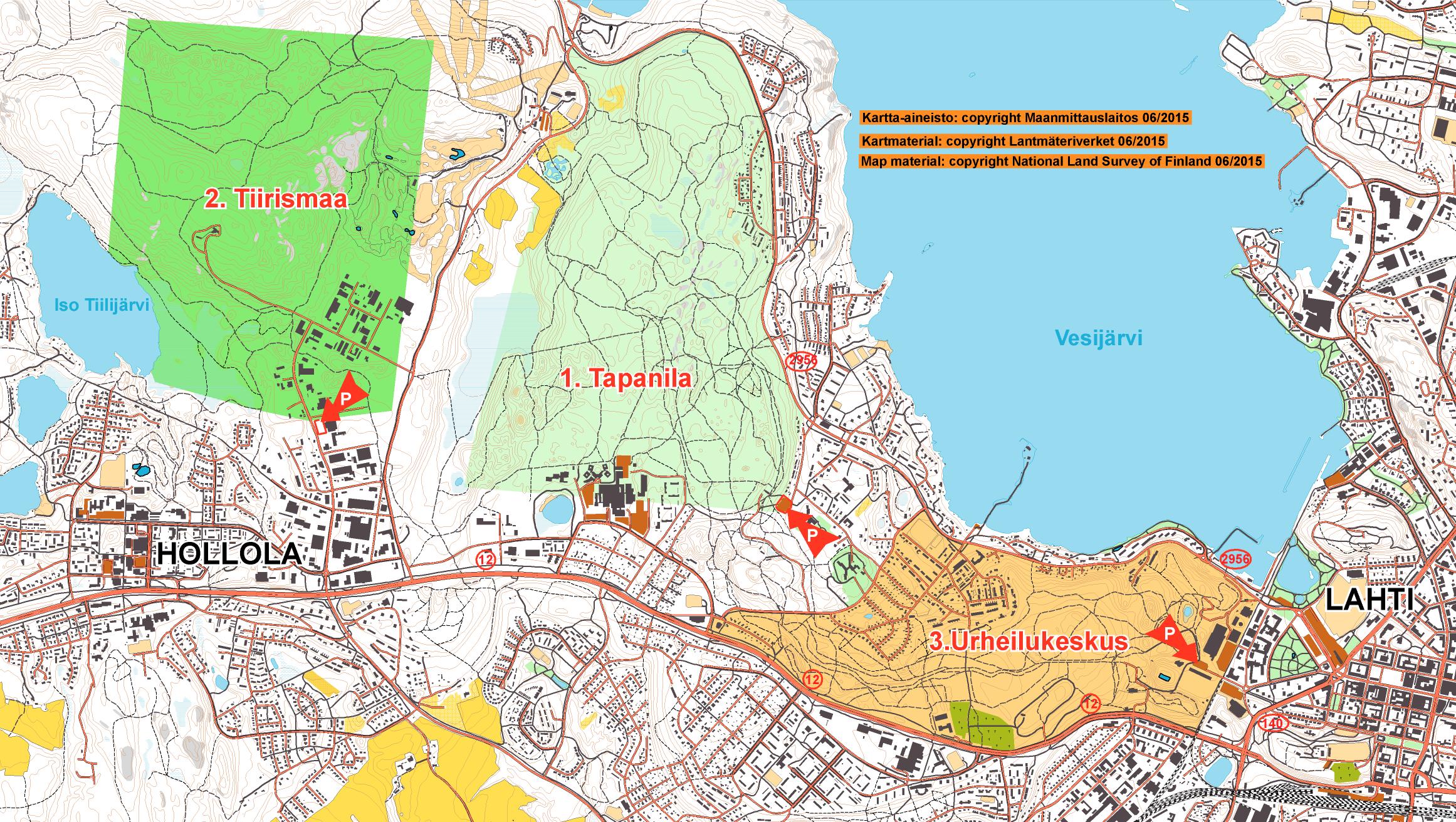
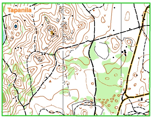
1. Tapanila: Opens at 21th of April
A 6,5 km long course which is especially intended primarily for night orienteering. The map is designed without any paths but for the young or more inexperienced runners there is also a map including paths available. The course designer is Teemu Niskanen.
An area with lots of paths and good runnability, heath forest with areas of large depressions and areas of small depressions.
Parking: There is a large parking area at the end of Mäkirinteenkatu (Street).
Mapping: Jarmo Pikkarainen in 2013. Updated in 2016.
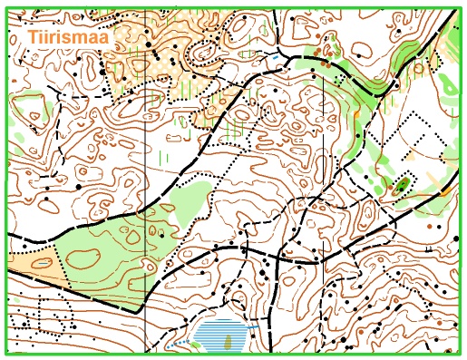
2. Tiirismaa: Opens at 21th of April
A technically very demanding middle distance training including plenty of control points. The course designer is Juhani Jaskari.
An extract from the statement of the course designer of Hollola-Rastit, Juhani Jaskari:
The ridges and slopes around the 327 meters high TV-mast at the top of Tiirismaa hill have a large number of adjacent re-entrants, hollows, mounds and rock faces. The area north of the mast is flatter but consists of lots of depressions.
Parking: Parking is available on the premises of SEW-EURODRIVE, Muovitie 1.
Mapping: Jarmo Pikkarainen 2015-2017
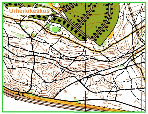
3. Urheilukeskus (Lahti Sports Center):
An outdoor recreation area with lots of paths and good runnability. Some areas have depressions.
There will be no control points in this area.
Parking: Parking is available at the Lahti Sports Center, Salpausselänkatu 7. Note that the parking time is restricted / parking disc.
Mapping: Jarmo Pikkarainen in 2016

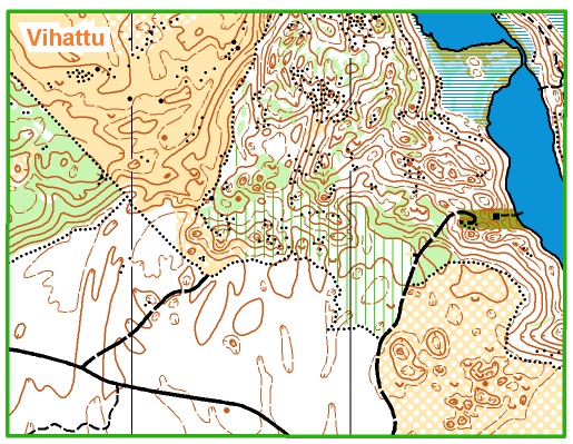
4. Vihattu: Opens at 28th of April
A training area in the immediate vicinity of the competition center. Due to the expected high volume of runners this area has been designed for all different distance trainings from which runners can design their own course. Also suitable for night orienteering. The course designer is Philipp von Arx.
Heath forest with depressions, in some places slow, stony ground.
Parking: in a gravel pit, N: 6764970 E: 411190 / ETRS-TM35FIN
Mapping: Arvo Paulin, Jarmo Pikkarainen in 2016-2017.
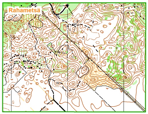
5. Rahametsä: Opens 21st May, 2018. (after the completion of the European Under 16 & 18 qualifying competition)
The area has a practice ban and training on old maps, for example, is prohibited until the completion of the European Under 16 & 18 qualifying competition.
Long distance training that offers longer route selection intervals. The terrain offers a variety of fast, flat heath forests and deep depressions. The total length of the training is approximately 12 km with plenty of correction possibilities. The course designer is Aleksi Anttolainen.
Parking: Suontaustantie, In a Meadow
Mapping: Rauno Asikainen, Jussi Silvennoinen, Kristian Liljeström in 2015.
Updated in 2018.
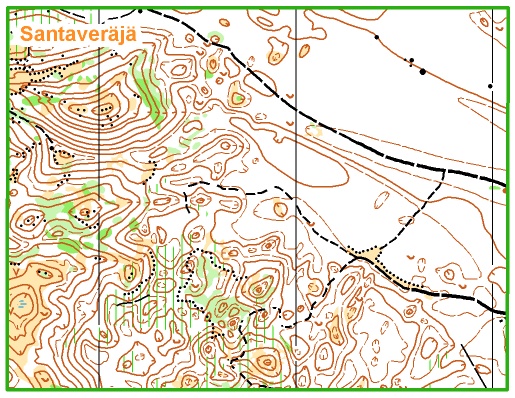
6. Santaveräjä: Opens at 28th of April
3 x 2 km interval training with forking (so called one-man relay) The total length of the training is 7 km. There are 4 different courses with forking.
The aim of the training is to offer different types of relay situations with diverse forking whilst being able to maintain a good running rhythm. The course designer is Aleksi Anttolainen.
Parking: on the both sides of the building in Tennilä’s sports field, Tenniläntie 800. Driving on the proper sports field is forbidden.
Mapping: Kristian Liljeström, Arvo Paulin, Jarmo Pikkarainen in 2015 – 2016.
Updated in 2018.
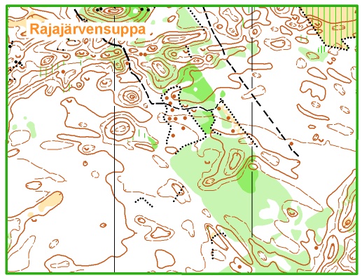
7. Rajajärvensuppa: Opens at 5th of May
The course designer, Minna Kauppi, has designed the training around the theme of “rhythm disorder”. The exercise is a straightforward directional orientation, but you have to be really careful. At times, progress can be slow with demanding depressions, so the pace needs to be slow and map reading becomes more crucial. It is also possible to practice the exercise as a relay, as there are 4 different forking paths available. The total length of the training is approximately 7 km. The course designer is Minna Kauppi
Parking: Suontaustantie, in a Meadow
Mapping: Jussi Silvennoinen, Kristian Liljeström, Jarmo Pikkarainen in 2015-2016:
Updated in 2017.
8. Kukonkoivu: Opens at 21th of April
A fast paced heath forest adjacent to the competition ground, where the northwestern part of the terrain has a more technically demanding area of depressions. Due to the expected high volume of runners this area has been designed for all different distance trainings from which runners can design their own course. The course designer is Juha Hirvonen.
Parking: Parking is available at Kukonkoivu Sports field which is located at the end of Juoksijantie. The parking site at Kukonkoivu will be closed after 12th June 2018. There will be a substitute parking place in Kukonkoivu during 13th June till 14th June, see the map lower. 15th and 16th June the terrain is available only from Jukola competition center.
Mapping: Arvo Paulin 2016, Jarmo Pikkarainen 2018
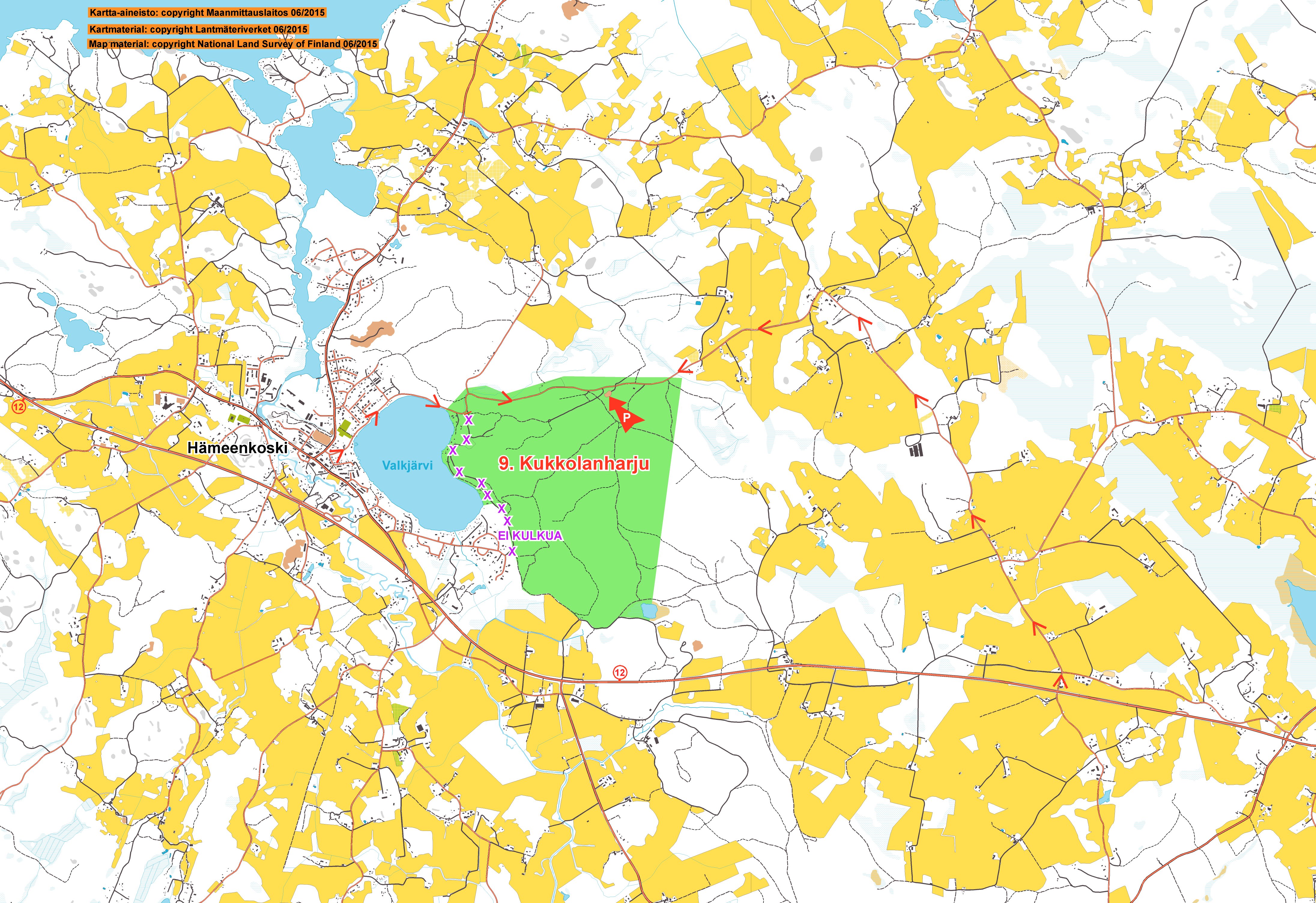
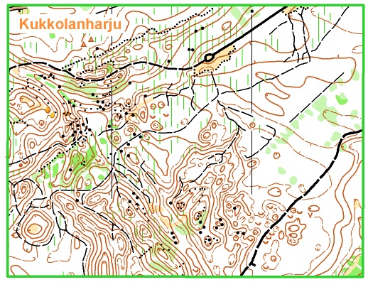
9. Kukkolanharju: Opens at 28th of April
The exercise has 3 separate routes of lengths 5.7 km, 5.0 km and 5.5 km. Each route is designed to be different and there are no same legs. Thus three runners can start at the same time or one runner can run several routes. The routes cross each other which means that paths created by earlier runners do not necessarily lead to the same control point.
The best area in the terrain where the routes have been designed is actually named mini-Hälvälä. All the same types of terrain can be found in the coming Jukola competition, but in a smaller area. The area offer both hilly and a more flatter area of depressions, trails, some rocky terrain and a small area of old mossy spruce. The course designer is Ari Anjala.
Parking: in a gravel pit, N: 6767140 E: 402800 / ETRS-TM35FIN
Mapping: Ari Anjala 2017