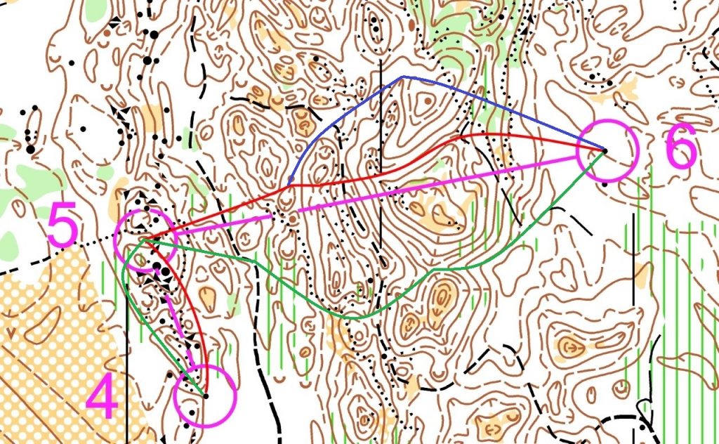
Merja Rantanen’s route Selection (red), reasons and tips for the navigators:
4-5
I would advance between check points slightly to the right. When I leave the fourth check-point I head to the right-hand side of the big depression. At about the halfway point there is a rocky area near a small hillock. From this point I approach the next big depression and from here I can see some large rocks. After I pass these rocks on the right-hand side, I see depressions to both my left and right but more importantly straight ahead I can see an upwards slope which, at the top, is where the control flag is positioned.
5-6
This is quite a challenging distance. I decide to proceed to the left side because I think it is the more secure route to take. When I leave the fifth check-point I confirm my route by taking a compass reading and look ahead into the distance where I can see a small hillock at the other side of a depression. I proceed up and over the hillock onto a flat area. I keep going until I come to a large depression on my left and just to confirm my position there should be a smaller depression to my right. As I pass by the tip of the big depression, I can see in front of me elongated, flat depression behind which there is a ridge which I know is followed by a huge depression. From the ridge, I proceed along the left-hand side of the slope of the big depression. Running off the depression is an elongated hollow (or tapered channel). From this channel, I can see the boundaries of the different forests and the path) and a track and I can use these to check that I start to climb the right side of the slope. On the top of the slope I am in a flat area and to my left is a small knoll which guides me to the sixth check-point which is located next to a large rock. Oh, how I enjoyed that, next it is carrying on in the same vein all the way to the finish.
Aleksi Anttolainen’s solution for route selection:
Between 4 and 5 it is important to avoid the rocky areas as the bottom of the depressions as they slow down the journey considerably. It doesn’t really matter which side of these you travel, the most important thing is to navigate the short distance carefully.
Between 5 and 6 there are many different alternatives for route choices. However, these varying route choices are all similar in terms of the time it takes to navigate. The most important thing is to navigate the demanding start as carefully as possible and to choose the route that suits you the best.
The red, more direct route, can be easily navigated by relying on the compass to facilitate navigation. However, the selection includes the most slow-moving part of the terrain in the form of steep slopes and rock formations. The green selection includes the most flat, well-grounded area, and the least steep areas, making it easier to keep a quicker pace – a favorite of mine. The final route is the blue route which is a slightly more direct route than the green route but using the ridges to avoid the steeper points.


